In the desert, one finds the way by tracing the aftermath of water.
~ Alison Deming, as quoted by Ken Lamberton
The All Souls Procession is moving this year. While the Finale site will remain the same, the starting point and route are changing.
History
This move is just the latest in a long history of changes. After all, the Procession at its heart is about living with change, with grief, with what has been lost and what has been gained.
The first Procession in 1990 was attended by only 25 people. Today close to 150,000 attend. What may have been lost in intimacy has been gained in impact.
From 1996-2016, we walked through the old commercial heart of the city. When the Procession began, downtown was a bit of a ghost town. Today it is alive. Bustling with activity. Full of restaurants and bars and other businesses.
In 2002, we moved from Saturday evening to Sunday to maintain the sacred heart of the Procession and clarify that while the Procession is a lot of fun, it is not primarily a party.
When streetcar development started in 2012, we moved the route from our long-time home on 4th Avenue to 6th Avenue, skirting downtown instead of processing along the heart of Congress. Once streetcar construction was completed, we found that the cost of shutting down the streetcar for the day was prohibitive for our tiny non-profit, so we maintained our 6th to Alameda to Congress route, shunted around the no-longer-ghostly city center.
Also in 2012, we outgrew our long-time Finale home at the Franklin Docks. We found a new home on the west side of the freeway near the Mercado San Agustin, thanks to the generosity of the Gadsden Company. But that home also brought challenges: it has required us to close the Congress Street freeway exits, substantially increasing our expenses.
The Procession has always evolved. For decades we have infused the city center with the energy and spirit of tens of thousands of people. Today, that center is thriving. But as it—and the Procession—has grown, we have been displaced from both our Finale location and our original Procession route.
We have been moving westward for years.
And now we are pulled by a spirit that is drawing us further westward, toward the liquid heart of Tucson, of Chuk-Son, of the ancient Hohokam villages: the Santa Cruz River.
When the River Ran
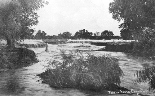
Today the Santa Cruz is dry and dusty most of the year, clogged with weeds and shopping carts. It is easy when we drive over it—or, rarely, walk beside it—to think it has always been this way. But the truth is something very different.
… the banks of the river, and the valley itself, are covered with poplars and willows, ash-trees and plantains, oaks and walnut trees … Some portions of the valley are of such grand, rich and simple beauty, as for instance Tumacacori and San Xavier del Bac, that they would be remarkable in any part of the world.”
~Julius Froebel, 1855, as quoted by Margaret Regan in “A River Runs Through It,” Tucson Weekly, 2001
Near San Xavier del Bac, the west side of the river was bordered by a massive mesquite bosque. Acres of mesquite trees, some of them sixty feet tall with trunks four feet in diameter.
The bottomlands on either side are covered, miles in extent, with a thick growth of giant mesquite trees, literally giants, for a person accustomed to the scrubby bush that grows everywhere in the desert regions of the southwest, can hardly believe that these fine trees, many of them sixty feet and over, really belong to the same species. This magnificent grove is included in the Papago Indian Reservation, which is the only reason for the trees surviving as long as they have, since elsewhere every mesquite tree large enough to be used as firewood has been ruthlessly cut down, to grow again as a straggly bush.
~Henry Swarth, ornithologist, 1902/1903, as quoted by Julio Luis Betancourt in “Tucson’s Santa Cruz River and the Arroyo Legacy,” 1990
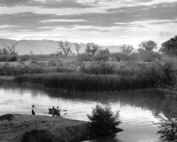
The historical Santa Cruz River was a shallow stream with a wide floodplain, not a deep arroyo at all. The water surfaced in places, dipped underground in others, pooled in ciénegas, sustained beavers and turkeys and ducks and fish and clams and frogs and turtles and humans. Water levels ebbed and flowed seasonally. There were floods, and the waters spread shallowly across the land.
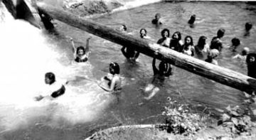
Even in the 1930s-50s, the river was radically different from what we know today.
The water was so clean, not polluted … it was beautiful. We used to have álamos (cottonwood trees), big, big, old trees, and we used to put ropes and tires on them and then we’d swing–BOOM!–right into the water.”
~Julia Soto, who grew up in Barrio Anita in the 1930s and 40s, A Path to the River, Memories of the Santa Cruz River and Barrio Anita
By the 1960s, the mesquite bosque was almost gone. The plummeting groundwater levels had pulled the water away from the trees’ roots, and they died of thirst. (Reference)
During the hundred years from Julius Froebel’s visit to the death of the mesquite bosques, Tucson’s population, irrigation, and water usage increased. The water tables dropped and the river began to change. The process was incremental—the kinds of changes that happen without us noticing. One year it’s a little drier, and then again the next. Or things are different than when we were kids, but maybe, we think, that’s only nostalgia. It’s easy to miss big changes that operate on a scale of decades.
But there was also a critical point, a pivotal moment when the shallow river began irrevocably to change into the arroyo we know today.
2017 marks the 130th anniversary of that moment:
In 1887 [Sam] Hughes saw a way to bring water from the Santa Cruz River to irrigate land north of town. He would crosscut a ditch into the river and divert subsurface water….on the east side of the river around St. Mary’s Road. [Floods] had an unexpected effect on Hughes’ ditch. The water started eroding the channel of the river from the [ditch] to the south. By the end of August the arroyo had crept…about 3 miles upstream. Within a year the river had cut a significant arroyo south to near Mission San Xavier del Bac. The big floods of 1890 worsened the situation. Today the river between Tucson and San Xavier is entrenched as much as 30 feet, in large part because of Hughes’ ditch.
~Tellman, Yarde, & Wallace, Arizona’s Changing Rivers: How People Have Affected the Rivers
Our Feet Trace Our River’s Scars
Today the river between Tucson and San Xavier runs—when it runs—in a deep arroyo. Sam Hughes’s ditch bears a large part of the blame. Historians believe that he cut into the east side of the Santa Cruz between St. Mary’s and what is now the Arizona School for the Deaf and Blind.
We will be walking on the west side of the Santa Cruz, paralleling the portion of the river that bore the brunt of Hughes’s cut.
We are the inheritors of consequences from the generations that came before us. And we are the inheritors of grief from those Ancestors who were good stewards of this land. We honor them by walking along the river.
In this age of climate change—of fires and hurricanes and drought and extinctions—we must remember and we must grieve. We cannot forget what has already been lost. We grieve this river that sustained this land and the people on it, the true heart of Tucson that has been devastated in just a few generations. We pour all our vast love and intention into the spirit of the water, to honor it, to offer it memory and life.
We invite you to join us.
Following the Ghost River
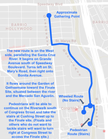 The new route is on the West side, paralleling the Santa Cruz River. It begins on Grande Avenue south of Speedway Boulevard., left on St. Mary’s Road, then right onto Bonita Avenue. It flows around the Garden of Gethsemane toward the Finale Site, situated between the river and the Mercado San Agustin. Pedestrians will be able to continue on the Riverwalk south of Congress Street and take the stairs at Cushing Street up to the Finale site. (Floats and others who do not want to tackle stairs will want to turn right at Congress Street to access the Finale site.)
For more on parking, check our parking tips page.
This route takes us through some of the oldest neighborhoods in the city—vital hearts, full of life. Menlo Park has been the home of the Finale Ceremony since 2012, and we have helped with the Día de San Juan Fiesta in this neighborhood for the past several years. This new route will bring us into Barrio Hollywood for the first time, as we process down the neighborhood’s main drag: Grande Avenue. We are working with the Barrio Hollywood Neighborhood Association, the neighborhood Cocio-Estrada American Legion Post 59, El Rio Neighborhood Center, and local businesses on some exciting new partnerships and projects. More details on those soon!
These neighborhoods are home to some extraordinary projects that are steeped in the deep history of Tucson and in a love for growing things—as well as for the water that sustains them. Mission Gardens in Menlo Park. Manzo Elementary’s Ecology Program in Barrio Hollywood. The brand new Barrio Hollywood Community Garden. Tucson Water’s proposed recharge project that will bring water back to the river at 29th Street, flowing north into Menlo Park and Barrio Hollywood. And of course, generations of families who have made their home along the river, memorializing their dead on its banks, visiting it to pray for rain on Día de San Juan, frightening children with tales of La Llorona stalking its depths, engaging with the river as it wove its way through their everyday lives.
The Santa Cruz has sustained people for 13,000 years, sustained agriculture for over 4,000 years. It is why Tucson is here after all. “We must reconnect with the river,” [Seth] says. “It’s not simply a flash flood basin running through our town that is empty 10 months a year….[W]e can’t ignore the river that runs right through our heart.”
~Ken Lamberton, quoting Seth Cothrun in “Revisiting the Dry River,” Edible Baja Arizona, July/August 2014
The Procession is powerful. It is full of spirit, full of love. We walk to remember. We walk for community. We walk where there is loss.
This is why we walk.
Resources
We encourage you to discover more about the history of the Santa Cruz—the gutted environmental heart of our city—and the efforts that are being made to preserve and restore the echoes of its spirit. We’ve collected a few links to get you started.
If you read nothing else, read these!
Overview by Margaret Regan, in the early days of the Rio Nuevo project: “A River Ran Through It,” Tucson Weekly, 2001
Overview by Ken Lamberton, who has written extensively about the river, with photography by All Souls Media Circle member, Jeff Smith: “Revisiting the Dry River,” Edible Baja Arizona, 2014
The latest report on the Santa Cruz’s flood risk and impacts that may have on recharge efforts, as reported on by Tony Davis: “Santa Cruz through downtown at risk for big flood, county says,” Arizona Daily Star, 2017
History
Barrio Anita, A Path to the River
Arizona’s Changing Rivers: How People Have Affected the Rivers
Looking Into the Westside: Untold Stories of the People, 1900-1997
Restoration Projects
From Ghost River to Living River
Friends of the Santa Cruz River
Replenishing a dried-up Arizona river a few drops at a time
Endangered fish reappear in the Santa Cruz River
Fish Thriving In Santa Cruz River Near Tucson
Santa Cruz river could flow again through downtown Tucson
Tucson Water hopes to have Santa Cruz River flowing within two years